Yesterday was our second day in Yellowstone. We did a lot of shit, but I will try to cover all the highlights.
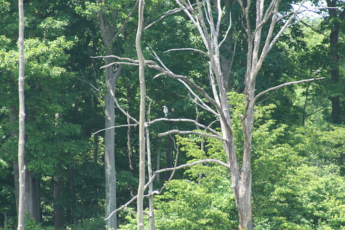
Driving in along the West Entrance Road, we stopped to see a bald eagle perched on a tree next to the river. They really are huge birds. I got some good looks with my binocs and Melissa took some good pictures. It was very cool, even if we did not get to see it fly. Next we stopped for a buffalo that was only about 10 yards from the road. He then started walking towards the car, so we got back in, and he passed withing less than 10 yards off us - again, Melissa got some good pics. I think we've decided at this point to no longer stop for elk or buffalo - we see them next to the road about every 5 minutes. We still need to see moose, bighorn sheep, bears, and wolves, though.
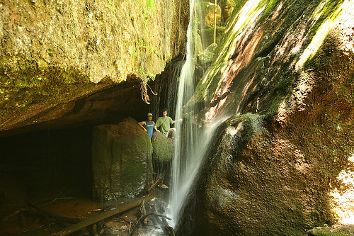
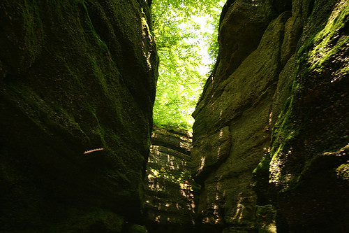
The hike we went on is past lots of big geyser fields, so we stopped at several of them. The geysers are very cool, but they all tend to run together in your mind - lots of bubbling pools of water, colorful drainage areas, boiling mud, spurting water, and tons of steam. I'll have Melissa post some pics. We also did see Old Faithful erupt from about a third of a mile away - it certainly is big and cool - very few of the geysers spurt the water more than a few feet into the air - but I dunno if it is worth all the hoopla. The geyser fields we saw today were, the Fountain Paint Pots group, Firehole Lake Drive, and Lower Geyser Basin. We skipped a few geyser fields, including the one with Grand Pismatic spring, so we have to go back to see a few more geysers sometime this week.
Our main hike of the day was a 6-mile (round-trip) there-and-back along the Delacey Creek Trail to Shoshone Lake, Yellowstone's second largest lake. We didn't exactly have the trail to ourselves - we passed several other hikers along the trail, but compared to the geyser fields we had just been at, we felt pleasantly alone. The trail is mostly flat with just a few small rolling hills, and very well marked and easy to follow. The only slight hitch was finding the trailhead - there is a turnout on the north side of the road about a quarter mile west of the picnic area (where we ate lunch) - the trailhead is on the opposite side of the road across from the western side of the turnout area. Basically, the trail itself is just a pleasant walk in the woods. It basically just cuts a path through the lodgepole forest just to the east of the meadow valley created by the rather small Delacey Creek. The first half of the trail is almost entirely forested, while the second half is mostly along the edge of the meadow - it makes for a good mix of forest and meadow scenery. At about the half way point, you can see the start to see the lake through the trees. Shoshone Lake itself is beautiful, completely ringed by forested mountains. There are lots of washed up logs to sit down on to enjoy the view. It was noticeably colder and windier by the lake - we hadn't brought our fleeces, so we resorted to rain jackets. All in all, a nice, relatively short hike.
Tuesday, September 18, 2007
Sunday, September 16, 2007
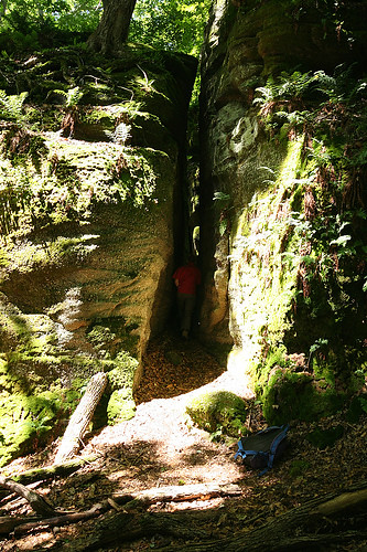
Yellowstone! - Artist Paint Pots
We're finally here - in Yellowstone! We just flew in this afternoon, so after dropping off our shit at the hotel and eating dinner, we just wanted a quick little trip to get a taste of what this place has to offer. So, went to see the Artist Paint Pots. It was about a 25-30 minute drive from the park border - getting around this park is going to require a TON of time in the car. Along the way we stopped and got within less than 10 yards of an elk, then a random geyser spewing sulfurous steam right of the road, and then again for a nice view of Gibbon Falls. We then went up the little side road that leads to the Artist Pain Pots trailhead and parked. It's just a 5 minute walk through regrowing burnt lodgepole to the boardwalks that take you around the thermal features. It's a short loop, maybe only half a mile, but we took our time and Melissa lots of pictures and it probably took us half an hour. There are several very cool features, including a small geyser continuously founting (I might have made that word up - but you get the idea) hot water at the base of the hill, lots of small colorful steaming holes all around, a big pot of boiling, spurting, gurgling mud up on top, some neat red holes in the ground filled with steaming milky blue water, and lots of other cool shit besides. All in all, I think it was a good choice for an easy hike on the first night. Seeing geysers and thermal features for the first time is truly impressive and awe-inspiring - nature is so much cooler than we can ever imagine!
I am probably way behind on this blog as far as gear purchases, pictures from hikes this summer, etc, etc. But now it's Yellowstone - it's kind of the this blog's reason for being and the impetus to start hiking in the first place. So all the undone shit from before takes a back seat.
I promise to post LOTS of Melissa's pictures!
Saturday, August 18, 2007
North Chagrin Reservation Metropark
I just got back from my first trip to a Cleveland Metropark (CMP)- a 7 mile hike in North Chagrin Reservation. It was me and Melissa today, and this was our longest hike yet. It was an absolutely beautiful day - around 70 degrees even at midday.
I downloaded a pretty good map from the website. However, the map is definitely lacking in detail around the parking lots, and got confusing over near the nature center where the density of trails was very high. Anyway, once we got on the trails they were pretty easy to follow, with only a couple of exceptions. However, the trails are really only marked at the major trail intersections, making it somewhat ambiguous at intersections with minor trails and with unmarked trails.
Anyway, we parked over at the nature center so we could look around the little ponds that are over there. They are pretty neat - the one was almost covered with lily pads. I used my new binocs to spot a small heron-ish bird, and there was a fun little turtle who kept hiding whenever Melissa tried to take a picture.
Our main path around the park consisted of the Castle Trail, up to the Scenic Loop Trail, (including a brief stint on Squire's Lane Trail), and then down Hemlock trail back to the parking lot. All of the trails were really pretty simlar - well-trodden trails through beech-maple forest with some hemlock groves. Most of the trails were on the edges of ravines with little creeks at the bottom. For the most part, the creeks were very small with very little water flow, but I can imagine they would be a bit more impressive after some good rain or snow-melt. Occasionally, the paths would dip into the ravines and back up, and the paths were well chosen to make for quite reasonable gradients. This added a bit of ruggedness to the trails, but the total elevation change from highest to lowest point was probably less than 200 feet. We saw very little wildlife on the trails, except for frogs and some fish, but we heard some interesting birds, including woodpeckers. For the most part we were alone on the trails and only passed someone occasionally, except there were noticeably more people within about half a mile of any parking lot.
New Cold/Rain Gear
Yesterday I got my first shipment of the new mostly cold and rain gear that I bought for both Melissa and me. I really wanted to have decent cold and rain gear for Yellowstone so that no matter what the weather we can get some good hiking in. I basically just looked at Campmor and Sierra Trading post for everything, and went with whichever place I could get the better deal. Generally, I have an easier time finding stuff at Campmor, but sometimes Sierra has some amazing deals. Anyway here's what we got:
Binocs - I wanted a pair of small hiking binocs, because my astro binocs are too big and bulky. I just got the cheapest I could find - a 10x28 pair for $25.
Rain Coat - The single item that started this whole shopping spree. I knew I needed a decent rain coat before Yellowstone - Melissa has the one her Dad gave her from Sheila. I was a bit disappointed to not find anything under $40. I went with the small lightweight version to fit in my bag as opposed to a very nice, heavier, bulkier one I found from Sierra on serious markdown.
Rain Pants - I figured these would be nice if we get caught in the rain, and were only 10 bucks each.
Rain Pack Covers - Again, another $10 a piece that I just thought would make life better in the rain.
Long Underwear - This seemed essential for cold weather, which is a definite possibility in Yellowstone, but also for hiking in the fall/winter in Ohio. As is all of our hiking clothing, made of nylon. Another $10+ each for three pieces - top and bottom for me, and bottom for Melissa (she already had a top - but I just realized I should check if it is nylon!).
T-shirts - I got Melissa two nylon hiking tees- partly for the nylon, partly to have tees to get beat up. I had bought two nylon tees from Campmor ($7 a piece!) a month or so ago.
Long Sleeve Tees - One for each of us.
Fleece Jackets - These were the biggest thing I was unsure about on the list - quite possibly overkill. But I am now thinking that they are going to be very useful in the fall (and quite possibly in Yellowstone) and we will be glad we have them - they really seem quite nice and warm. I guess the question was really whether hoodies wouldn't work just as well, but we really got these for the same reason we got a lot of the other clothing - to be lightweight, nylon, and OK to beat up. Besides they were only $25 each and they look pretty nice - especially the color I got for Melissa.
All the stuff above was from Campmor. The stuff below I should get from Sierra on Monday.
Socks - We wanted to both have 3 pairs of liners/socks before Yellowstone. I needed 2 liners and 2 socks, and Melissa got 3 liners and 1 sock.
Convertible Pants - We wanted to have dedicated hiking pants for the usual reasons - nylon and beat-up-able. The convertibles will be nice too, since they can be either shorts or pants.
That's it! Over $300 :(. Stuff still to think about getting - one more t-shirt for each of us, a water treatment kit for emergencies, a nylon long underwear shirt for Melissa, waterproof gloves... I am sure there is plenty of other shit.
Monday, August 13, 2007
Melissa's Mom's House
This weekend we were back in Wilkes-Barre for Melissa's wedding shower. On Sunday morning, I finally had some time to go on a hike with Tony through their woods. We were gone for around 2 hours, and covered maybe 5 miles.
We started on the path back behind the garage, then went back behind the nursery out to the power lines. We went up the hill to the left, into the woods on the other side, down the hill to the hemlock grove, back to the power lines, up the other side and then to the gas line and home.
The most important thing I learned is where the house is in relation to the power lines - I had it all wrong a few months ago and me and Andreas got quite lost. To get home from the bottom of the power lines you have to make a RIGHT up the hill and take a trail back on the SAME SIDE YOU CAME IN ON (this is assuming you've come down the path from behind the nursery). So I think I have my bearings a lot better now and should not get quite so lost again.
I also got to try out Tony's GPS, which is just a basic Garmin eTrex. The whole first mile or two of the hike, it could not pick up a signal as we were walking through the woods. However, when we got to a clearing and stood still, it managed to find a signal in a couple of minutes. After that, that signal was intermittent depending on the thickness of the canopy - in fields and under some of the canopy, it worked fine, but under the densest canopy it dropped the signal. Because we did not have a signal for so long, and because the batteries were close to dying, I did not get to try out all the features. However, I was impressed when at the end it was able to automatically detect that we were walking towards home, and gave the remaining distance, and even estimated the walking time based on our speed. I quite like the compass (even though you have to be moving) and speed features.
I have an eTrex H - the same basic design with a new high sensitivity receiver - on pre-order from TigerGPS. Tee original release date was supposed to be three weeks ago, but it has been pushed back. Supposedly, it should be in any day now.
Wednesday, August 1, 2007
Mentor Lagoons Nature Preserve
Wow, it's been a long time since I managed to go on a hike. I've just been extremely busy lately with moving, parents visiting, and god knows what else. I think the other thing was that after we moved, I didn't really know exactly where all my gear was, so I guess that kind of discouraged me a little more.
Anyway, on Sunday I finally went on a hike! I went to Mentor Lagoons Nature Preserve, up along the lake, out just past Willoughby. I did the main 3 mile loop around the preserve. I downloaded a map from their website, but a decent trail map was also available at the trailhead. The loop starts on the main park trail, called Lakefront Trail, which is wide a gravel. After a short distance, however, I followed a small footpath the leads off to the right of the trail into the woods, which then just parallels the main trail, but I liked that it was more wooded and less crowded.
Soon, there is a wide wooden trail called Marsh Rim Trail that breaks off to the right and heads east. I followed this trail for a while until I hit the eastern edge of the preserve, where there is a sign that marks the end of the nature preserve and the beginning of a different Mentor Marsh State Nature Preserve. The trail continued east into the SNP, but I followed the Lakefront Loop trail North up to Lake Eerie. This trail is also a wide, wooded trail all the way to the lake. The dominant types of trees I spotted were some types of maple, beech, and what I think were chestnut. Anyway, the forest had a neat look to it because there was almost no undergrowth, just flat ground and vertical tree trunks.
Once you get to the lake, the trail meets up again with the Lakefront trail, which I followed back southwest for a while. However, the Lakefront Trail continues further to the northeast. Also, there are a few narrow footpaths that lead down the 15 foot ledge to the beach that lines the lake. Anyway, I headed down Lakefront Trail, and appreciated that since the sun was getting low in the west, I had some shade from the horizontal shadows, on an otherwise open trail.
Eventually, I made a right hand turn onto Woods Trail and once again entered the maple, beech forest. Leading off to the right of this trail were a couple of very wide service trails, but I kept heading west along the main trail. This is a short trail section, which takes you out to the beach along the lake.
The map seems to call this section Shoreline Loop trail, but really there is no proper trail, and you are just walking along the sand on the shore of the lake. It seems that if you prefer, you could get onto the beach down one of the little paths around where Lakefront Loop meets Lakefront Trail and then walk all the way back along the beach, skipping Lakefront and Woods. But I found that while walking on the sand is pleasant, it is much more tiring than walking on more solid ground. The short section of beach along Shoreline Loop was a nice change, but if it was much longer it could have become difficult. I really appreciated having my new walking stick to help with plodding through the sand, and found that it worked best with the wide circular snow attachment.
The last bit of the hike is on Marina Overlook Trail. The first half of this trail is basically just the road that runs down the marina, so I got to walk past a bunch of porta-johns and ugly, fat, topless men sitting around their boats. But the second half turns up into the woods and lets you out onto Lakefront Trail, just a couple hundred feet from the parking lot.
All told, it is an easy hike, just under 4 miles. The trails were very well marked and easy to follow, and there are decent maps to follow. The forest has an interesting look because of the lack of undergrowth. I saw very little wildlife, other than numerous purple martins around the parking lot. The short beach section was definitely a nice change of pace. I was glad that I went in the early evening when the sun was low, because there about half the trail is exposed and would be quite hot on a sunny afternoon. Overall, it is a nice hike, but nothing spectacular.
I had to do this hike by myself because Melissa threw her back out that morning and was barely mobile. No Melissa also means no pictures.
Tuesday, June 19, 2007
Library Books
Over the weekend I ordered a bunch of books from the library on Ohio hiking and wild life. Yesterday I got the Ohio State Park's Guidebook, but was very disappointed because it is almost exactly the same info as on the Ohio State Park's webpage, sometimes verbatim.
Tonight I just picked up the Trees of Ohio and Birds of Ohio field guides. They are both pocket sized books by the same author, Stan Tekiela, which are basically organized by one species per page (left side has pictures, right side descriptions). I have already used the bird book to help identify some of the birds that I saw at Tinker's Creek this weekend, including the gray catbird, eastern kingbird, and the possible northern harrier. Overall, it seems quite a nice book, but I am not a huge fan of the organizational scheme. It is organized primarily by color (loosely by size within colors), whereas I have always found sorting by bird type (such as the Audubon Society books) to be easier - it is easy to tell the difference between a hawk, a duck, and a finch, but not always easy to tell if a bird is predominantly grey, white, or brown. I have not had a chance to use the trees book, but am very excited about doing so.
I also got a hiking book, Hiking Ohio: Scenic Trails of the Buckeye State by Robert Folzenlogen. It's a bit old, but how much can the trails really change in 17 years? I just flipped through it briefly, but it seemed to have quite a few nice hikes in the area. I will probably take it to work and photocopy the hikes that look good.
I've got several more fun books coming!
Emergency Kit
I bought a small emergency kit last week to keep in my hiking pack. The basic kit is the Personal Ten Essentials RT made by Adventure Medical Kits, which I got from Campmor. It's got a basic first aid kit, firestarter, space blanket, and whistle. I also got some iodine water treatment tablets to keep in there.
I bought two other things while I was at it. A cheap plastic poncho, which is sort of an emergency item, and a strap for my glasses, which will be useful for other activities like softball.
All that stuff is stored in a ziploc baggie in my pack, with several other gallon baggies and a trash bag to stow my pack in in a heavy downpour.
Sunday, June 17, 2007
Tinker's Creek SP
Yesterday Melissa and I went hiking at Tinker's Creek State Park and Nature Preserve. That is, the SP and NP are adjacent but two separate areas.
We started in the state park area and basically just did the main loop around the pond (EDIT: actually, not the short loop that just goes around the edge of the main lake, but the longer loop that goes back through the marshes and ponds to the
northeast), including a few detours and spur trails, totalling maybe two miles. The parking area had a porta-john and the admin building was closed up and looked completely disused. The trail was obvious and easy to follow in all but one or two areas, but it was not well kept - fairly overgrown with grass (if I go again I will know to wear long pants) and several of the bridges/boardwalks were in pretty bad disrepair. The worst section was a little stream crossing right before the first natural pond (the main lake at the parking lot is man-made) where there was no obvious path and there was only a few remains of an old wooden bridge. Still, overall it was a nice trail, and not at all what I would call difficult. Very much more secluded than at Nelson-Kennedy last week - after we left the main lake we didn't see anyone else on the trail. The natural ponds had a cool swampy overgrown feeling, and the surfaces were covered in green plants and algae. We saw more wildlife too - lots of frogs and toads; geese, including fledglings, on the main lake; a great blue heron; a snake; and at least a half dozen different other birds. Melissa seemed pretty out of it, so we didn't go back and do all of the rest of the trails. After we got back, we rested for a few minutes and I had lunch in the picnic pavilion while Melissa played on the swingset! The map of the park I downloaded was decent enough, but it is tough with a map like that without more detail. For instance, when we were finishing the trail coming back to the parking lot from the west side, the end of the trail was actually gravel road. But this wasn't marked at all on the map, so I got confused for a while trying to figure out what the map was calling a trail and what was a road. It turns out that those gravel roads are the trails (there are two leading to different trails). It was a moment when it was clear to me just how useful a GPS would be - but I will write more about GPS's later.
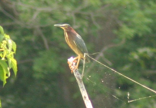
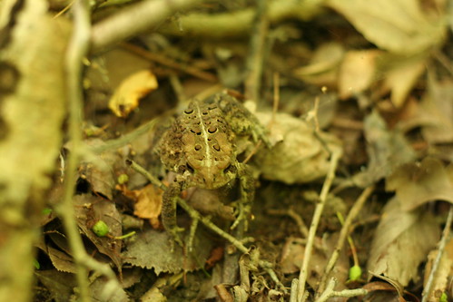
The second half of the hike was in the nature preserve area, which starts from a different trailhead a couple miles down the road, with a small parking area. This trail was much more well kept with wider paths and newish boardwalks - again I think we totalled something like two miles (EDIT: The Hiking Ohio book lists this complete hike as 2.75 miles). A couple hundred yards from the trailhead there is a little information post with pamphlets that include some interesting detail about the area and a decent trail map. The trail starts with a deciduous/conifer forest area, but quickly gets to the ponds, marshes, and wetlands that are the main feature of the preserve. The wetlands are really beautiful. Along the path there are several cool small ponds, but there are several places where you can see the exanse of open marsh for half a mile or more - especially at the far southern tip of the trail and the observation deck built just off a small eastern spur trail. It's really a shame that the signs of civilization are so close, however - a railroad track marks one edge of the swamp while on the other side the back of a strip mall is visible. We saw dozens of cool bird species, including a beautiful green heron (see picture) from just about 30 yards. There were also a couple of great blue herons (although we never got closer than a hundred yards or so), geese and wood ducks both with fledglings, an eastern kingbird, a gray catbird, a cardinal, a few red winged blackbirds, and plenty of other smaller birds that I can't identify. I saw one soaring bird from about a quarter of a mile, which kind of looked like a northern harrier, which makes sense because they like swamps, but they are supposed to only be around in the winter - I dunno. We also saw frogs, turtles, fishes, a raccoon, dragon flies, butterflies, and unfortunately plenty of mosquitoes and buzzing bugs. There were several beautiful wildflower species, my favorite being some bright yellow flowers growing from the lily pads (Melissa was getting pretty worn out by this point, so she didn't get me a picture of them). There is a small spur loop trail that goes to a pond that is supposed to be a beaver pond with a lodge (Lonesome Pond), but other than some stripped and gnawed trees, we didn't see any signs of the beavers or the lodge- but then again we don't really know what to look for. With all of the wildlife, I got good use out of my binocs. Overall, this was my favorite trail of the season so far.
This was also our first chance to try out our new packs. They are definitely a little heavy filled with water, but the packs are well designed and do a great job of distributing the weight well. I also brought along my binocs, emergency kit, and a sandwich, and had plenty of room for a sweatshirt or whatever had I needed it. Melissa fit her camera with room for a few extras as well. After the hike we both still had 1/2 - 2/3 of our resevoirs full of water, and neither of us felt that we conserved in any way. This bodes well for longer trips when we will need to carry that much water.
My boots were feeling quite good again. While my feet were definitely getting sore by the end, I could tell they would have been a lot worse without the good boots. The only even slight problem was just a little bit of pinching in my right little toe - but its possible that I was just imagining it since me feet hurt in general. Had we been doing an all-day hike, it would have been about time for an hour or so to sit down, eat lunch, and let our feet air out.
As usual, all of these pictures are Melissa's. I should note, however, that I blew up the green heron picture quite a bit, even though she generally disapproves of such "cheating". I say it's using your equipment to it's full capabilities!
We started in the state park area and basically just did the main loop around the pond (EDIT: actually, not the short loop that just goes around the edge of the main lake, but the longer loop that goes back through the marshes and ponds to the
northeast), including a few detours and spur trails, totalling maybe two miles. The parking area had a porta-john and the admin building was closed up and looked completely disused. The trail was obvious and easy to follow in all but one or two areas, but it was not well kept - fairly overgrown with grass (if I go again I will know to wear long pants) and several of the bridges/boardwalks were in pretty bad disrepair. The worst section was a little stream crossing right before the first natural pond (the main lake at the parking lot is man-made) where there was no obvious path and there was only a few remains of an old wooden bridge. Still, overall it was a nice trail, and not at all what I would call difficult. Very much more secluded than at Nelson-Kennedy last week - after we left the main lake we didn't see anyone else on the trail. The natural ponds had a cool swampy overgrown feeling, and the surfaces were covered in green plants and algae. We saw more wildlife too - lots of frogs and toads; geese, including fledglings, on the main lake; a great blue heron; a snake; and at least a half dozen different other birds. Melissa seemed pretty out of it, so we didn't go back and do all of the rest of the trails. After we got back, we rested for a few minutes and I had lunch in the picnic pavilion while Melissa played on the swingset! The map of the park I downloaded was decent enough, but it is tough with a map like that without more detail. For instance, when we were finishing the trail coming back to the parking lot from the west side, the end of the trail was actually gravel road. But this wasn't marked at all on the map, so I got confused for a while trying to figure out what the map was calling a trail and what was a road. It turns out that those gravel roads are the trails (there are two leading to different trails). It was a moment when it was clear to me just how useful a GPS would be - but I will write more about GPS's later.
The second half of the hike was in the nature preserve area, which starts from a different trailhead a couple miles down the road, with a small parking area. This trail was much more well kept with wider paths and newish boardwalks - again I think we totalled something like two miles (EDIT: The Hiking Ohio book lists this complete hike as 2.75 miles). A couple hundred yards from the trailhead there is a little information post with pamphlets that include some interesting detail about the area and a decent trail map. The trail starts with a deciduous/conifer forest area, but quickly gets to the ponds, marshes, and wetlands that are the main feature of the preserve. The wetlands are really beautiful. Along the path there are several cool small ponds, but there are several places where you can see the exanse of open marsh for half a mile or more - especially at the far southern tip of the trail and the observation deck built just off a small eastern spur trail. It's really a shame that the signs of civilization are so close, however - a railroad track marks one edge of the swamp while on the other side the back of a strip mall is visible. We saw dozens of cool bird species, including a beautiful green heron (see picture) from just about 30 yards. There were also a couple of great blue herons (although we never got closer than a hundred yards or so), geese and wood ducks both with fledglings, an eastern kingbird, a gray catbird, a cardinal, a few red winged blackbirds, and plenty of other smaller birds that I can't identify. I saw one soaring bird from about a quarter of a mile, which kind of looked like a northern harrier, which makes sense because they like swamps, but they are supposed to only be around in the winter - I dunno. We also saw frogs, turtles, fishes, a raccoon, dragon flies, butterflies, and unfortunately plenty of mosquitoes and buzzing bugs. There were several beautiful wildflower species, my favorite being some bright yellow flowers growing from the lily pads (Melissa was getting pretty worn out by this point, so she didn't get me a picture of them). There is a small spur loop trail that goes to a pond that is supposed to be a beaver pond with a lodge (Lonesome Pond), but other than some stripped and gnawed trees, we didn't see any signs of the beavers or the lodge- but then again we don't really know what to look for. With all of the wildlife, I got good use out of my binocs. Overall, this was my favorite trail of the season so far.
This was also our first chance to try out our new packs. They are definitely a little heavy filled with water, but the packs are well designed and do a great job of distributing the weight well. I also brought along my binocs, emergency kit, and a sandwich, and had plenty of room for a sweatshirt or whatever had I needed it. Melissa fit her camera with room for a few extras as well. After the hike we both still had 1/2 - 2/3 of our resevoirs full of water, and neither of us felt that we conserved in any way. This bodes well for longer trips when we will need to carry that much water.
My boots were feeling quite good again. While my feet were definitely getting sore by the end, I could tell they would have been a lot worse without the good boots. The only even slight problem was just a little bit of pinching in my right little toe - but its possible that I was just imagining it since me feet hurt in general. Had we been doing an all-day hike, it would have been about time for an hour or so to sit down, eat lunch, and let our feet air out.
As usual, all of these pictures are Melissa's. I should note, however, that I blew up the green heron picture quite a bit, even though she generally disapproves of such "cheating". I say it's using your equipment to it's full capabilities!
Wednesday, June 13, 2007
New Packs
Melissa and I got our new packs today. We both went for Camelbak 100 oz daypacks, hers the designed-for-women Isis, and mine is the Rim Runner. I have used a Camelbak bag a couple times before, and they really are very convenient. We decided that we really couldn't go wrong getting the 100 oz reservoirs over the 70 oz models. They do cost slightly more, but we are definitely going to need to carry that much water at times. I got a really good deal on Melissa's at South Summit. I got a decent deal on mine at Campmor. I also bought a compass that was on sale, because a compass seems like a good thing to have. It clips onto my bag and even has a nifty little temperature sensor.
My first impressions of the packs is quite positive, but I haven't had a chance to use them at all. There looks to be enough space for all the basic hiking kit, a few warm clothes, and a lunch. They seem to have an extraordinary amount of little hoops, clips, clasps, zippers, etc. on the outside of the bag to strap on extra gear or just keep the bag tight - I am really nor sure how much of it is entirely necessary, but we'll see. As we get a chance to test them out, I will make sure to comment on their performance. And I will make sure Melissa gets some pictures of them in use.
My first impressions of the packs is quite positive, but I haven't had a chance to use them at all. There looks to be enough space for all the basic hiking kit, a few warm clothes, and a lunch. They seem to have an extraordinary amount of little hoops, clips, clasps, zippers, etc. on the outside of the bag to strap on extra gear or just keep the bag tight - I am really nor sure how much of it is entirely necessary, but we'll see. As we get a chance to test them out, I will make sure to comment on their performance. And I will make sure Melissa gets some pictures of them in use.
Sunday, June 10, 2007
Nelson-Kennedy Ledges SP
Yesterday I went to Nelson-Kennedy Ledges State Park for my first hike in my new boots, and my first since I decide to take up hiking as a serious hobby. It's about an hour drive, which was fun with 5 people (Me, Melissa, Andreas, Tim, and Marielle) packed into a Honda Civic. I was actually a bit worried on the way out that it would not be worth the uncomfortable trip. Luckily, my fears were unfounded.
The park exists because it has lots of cool rock formations created by ancient glaciers dumping a bunch of boulders in a big pile. The trail map that I had only indicated about 1.8 miles of marked trail. We had chosen a short hike because Melissa was not feeling well, and because I wanted to break in my boots. The park is small, but filled with tons of little rock caves, cliffs, ravines, ledges, and climbs to explore. Between those exploring side trips and a couple miles of unmarked trail that we went on, we probably went closer to 4 miles total.
All of the marked trails in the park start from the same trailhead. Several of the trails simply run parallel to each other (S from the trailhead). The first (blue) basically runs along the bottom base of the rock ledges, the second (red) goes back over, under, and through some of the cool ravines and cliffs, and the third (white) sort of loops around up on top of the rock formations. We definitely followed the first two well beyond (S) their marked ends, farther into the woods. There are a few cool rocks back that way, but the trails do take you through the best sections. Also, at the end of the marked blue and red trails, there are some neat caves, with a creek coming down from a small waterfall which you can easily see from the white trail. There is one final trail, which runs N of the trailhead that takes you to a few more cool caves and to a neat, somewhat bigger waterfall. This one is maybe 40-50 feet high, but the water volume is pretty low, just a small creek about a meter wide a couple inches deep. We didn't see much wildlife other than a couple of frogs (one almost the size of my fist), but we were making plenty of noise and weren't really looking. I brought along my binocs, but never actually had a use for them.
The trails were not particularly well marked, but it's not a big deal since it is a pretty small park, and half the fun is going off the trails climbing and exploring in the various rock formations. The biggest downside was definitely the man-made junk all through the park. In most of the caves there were lighters and beer cans littered about. The trails rarely get out of sightline, and never get out of earshot, of the road. We passed a few other groups of people in the park, but the trails were certainly not crowded. This is definitely not a park for anyone who wants to get away from civilization and feel alone in the wilderness. But I highly recommend it for a fun hike with some scrambling around on rocks.
It was a gorgeous day, about 70 and sunny. We brought bagel sandwiches to eat after the hike, but everyone was hungry, so we ate before instead. We did not carry any water with us, so we were all extremely thirsty by the end. It was fine, however, since we were only gone for 2 hours, and we never really got very far from the car. By next weekend we should have our new backpacks with our water bladders to carry plenty with us. Also, it will be nice to have the packs for Melissa's camera, especially since some of the rock climbing required two hands and we had to pass the camera around to keep it safe. My binocs were OK since I carried them in the case because I am missing one of the lens caps.
My boots worked out well. They had pretty good traction, but I did still slip on a few of the wet rocks. I really appreciated the ankle support. I have two minor complaints. The first is that my feet are different by about a half size, so one boot fits perfectly and the other is just a touch loose. I think it will be fine, however, and I had no blisters or irritation whatsoever - amazing for the first time wearing brand new shoes. The second minor thing is that the top of my left ankle was a bit sore. I think it mostly had to do with how I had the laces tied and it should also be fine, but it is something to look out for.
My fiance Melissa took all of the pictures I posted here. She is an awesome photographer. One of these days I will make a post about here photography-awesomeness.
Friday, June 8, 2007
New Boots
I got my new hiking boots today! They are Asolo FSN 95 Gore-Tex lined boots. I got an awesome deal on them from Sierra Trading Post - $100 for boots that retail for $160. I read lots of awesome reviews of them at Trailspace. I also got a cheap pair hiking socks and sock liners from STP.
These are the first pair of hiking boots I have ever owned. They feel like little tanks for my feet. The soles definitely feel huge, and I even wear walking boots everyday. But mostly the ankle support is amazing, like nothing I have ever worn before. They feel pretty awesome.
I'm gonna get Melissa to take a picture of them for me to post soon.
Subscribe to:
Posts (Atom)