I just got back from my first trip to a Cleveland Metropark (CMP)- a 7 mile hike in North Chagrin Reservation. It was me and Melissa today, and this was our longest hike yet. It was an absolutely beautiful day - around 70 degrees even at midday.
I downloaded a pretty good map from the website. However, the map is definitely lacking in detail around the parking lots, and got confusing over near the nature center where the density of trails was very high. Anyway, once we got on the trails they were pretty easy to follow, with only a couple of exceptions. However, the trails are really only marked at the major trail intersections, making it somewhat ambiguous at intersections with minor trails and with unmarked trails.
Anyway, we parked over at the nature center so we could look around the little ponds that are over there. They are pretty neat - the one was almost covered with lily pads. I used my new binocs to spot a small heron-ish bird, and there was a fun little turtle who kept hiding whenever Melissa tried to take a picture.
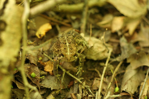
Our main path around the park consisted of the Castle Trail, up to the Scenic Loop Trail, (including a brief stint on Squire's Lane Trail), and then down Hemlock trail back to the parking lot. All of the trails were really pretty simlar - well-trodden trails through beech-maple forest with some hemlock groves. Most of the trails were on the edges of ravines with little creeks at the bottom. For the most part, the creeks were very small with very little water flow, but I can imagine they would be a bit more impressive after some good rain or snow-melt. Occasionally, the paths would dip into the ravines and back up, and the paths were well chosen to make for quite reasonable gradients. This added a bit of ruggedness to the trails, but the total elevation change from highest to lowest point was probably less than 200 feet. We saw very little wildlife on the trails, except for frogs and some fish, but we heard some interesting birds, including woodpeckers. For the most part we were alone on the trails and only passed someone occasionally, except there were noticeably more people within about half a mile of any parking lot.
Showing posts with label pictures. Show all posts
Showing posts with label pictures. Show all posts
Saturday, August 18, 2007
Sunday, June 17, 2007
Tinker's Creek SP
Yesterday Melissa and I went hiking at Tinker's Creek State Park and Nature Preserve. That is, the SP and NP are adjacent but two separate areas.
We started in the state park area and basically just did the main loop around the pond (EDIT: actually, not the short loop that just goes around the edge of the main lake, but the longer loop that goes back through the marshes and ponds to the
northeast), including a few detours and spur trails, totalling maybe two miles. The parking area had a porta-john and the admin building was closed up and looked completely disused. The trail was obvious and easy to follow in all but one or two areas, but it was not well kept - fairly overgrown with grass (if I go again I will know to wear long pants) and several of the bridges/boardwalks were in pretty bad disrepair. The worst section was a little stream crossing right before the first natural pond (the main lake at the parking lot is man-made) where there was no obvious path and there was only a few remains of an old wooden bridge. Still, overall it was a nice trail, and not at all what I would call difficult. Very much more secluded than at Nelson-Kennedy last week - after we left the main lake we didn't see anyone else on the trail. The natural ponds had a cool swampy overgrown feeling, and the surfaces were covered in green plants and algae. We saw more wildlife too - lots of frogs and toads; geese, including fledglings, on the main lake; a great blue heron; a snake; and at least a half dozen different other birds. Melissa seemed pretty out of it, so we didn't go back and do all of the rest of the trails. After we got back, we rested for a few minutes and I had lunch in the picnic pavilion while Melissa played on the swingset! The map of the park I downloaded was decent enough, but it is tough with a map like that without more detail. For instance, when we were finishing the trail coming back to the parking lot from the west side, the end of the trail was actually gravel road. But this wasn't marked at all on the map, so I got confused for a while trying to figure out what the map was calling a trail and what was a road. It turns out that those gravel roads are the trails (there are two leading to different trails). It was a moment when it was clear to me just how useful a GPS would be - but I will write more about GPS's later.
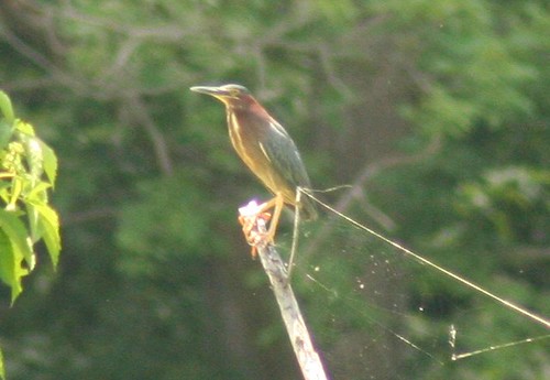
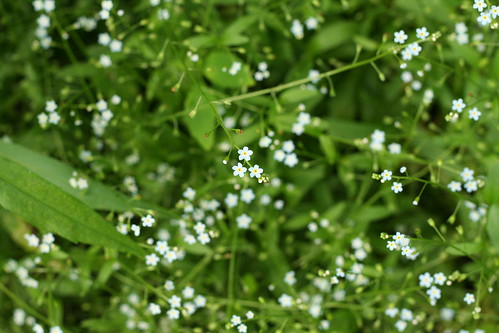
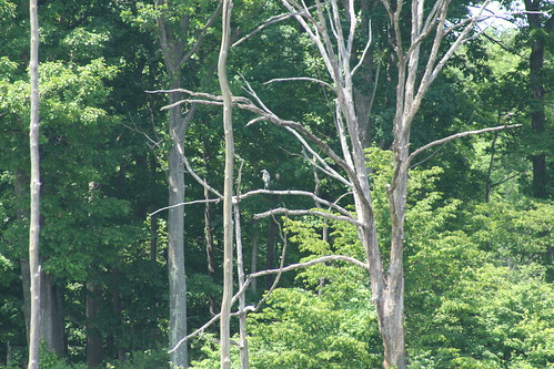
The second half of the hike was in the nature preserve area, which starts from a different trailhead a couple miles down the road, with a small parking area. This trail was much more well kept with wider paths and newish boardwalks - again I think we totalled something like two miles (EDIT: The Hiking Ohio book lists this complete hike as 2.75 miles). A couple hundred yards from the trailhead there is a little information post with pamphlets that include some interesting detail about the area and a decent trail map. The trail starts with a deciduous/conifer forest area, but quickly gets to the ponds, marshes, and wetlands that are the main feature of the preserve. The wetlands are really beautiful. Along the path there are several cool small ponds, but there are several places where you can see the exanse of open marsh for half a mile or more - especially at the far southern tip of the trail and the observation deck built just off a small eastern spur trail. It's really a shame that the signs of civilization are so close, however - a railroad track marks one edge of the swamp while on the other side the back of a strip mall is visible. We saw dozens of cool bird species, including a beautiful green heron (see picture) from just about 30 yards. There were also a couple of great blue herons (although we never got closer than a hundred yards or so), geese and wood ducks both with fledglings, an eastern kingbird, a gray catbird, a cardinal, a few red winged blackbirds, and plenty of other smaller birds that I can't identify. I saw one soaring bird from about a quarter of a mile, which kind of looked like a northern harrier, which makes sense because they like swamps, but they are supposed to only be around in the winter - I dunno. We also saw frogs, turtles, fishes, a raccoon, dragon flies, butterflies, and unfortunately plenty of mosquitoes and buzzing bugs. There were several beautiful wildflower species, my favorite being some bright yellow flowers growing from the lily pads (Melissa was getting pretty worn out by this point, so she didn't get me a picture of them). There is a small spur loop trail that goes to a pond that is supposed to be a beaver pond with a lodge (Lonesome Pond), but other than some stripped and gnawed trees, we didn't see any signs of the beavers or the lodge- but then again we don't really know what to look for. With all of the wildlife, I got good use out of my binocs. Overall, this was my favorite trail of the season so far.
This was also our first chance to try out our new packs. They are definitely a little heavy filled with water, but the packs are well designed and do a great job of distributing the weight well. I also brought along my binocs, emergency kit, and a sandwich, and had plenty of room for a sweatshirt or whatever had I needed it. Melissa fit her camera with room for a few extras as well. After the hike we both still had 1/2 - 2/3 of our resevoirs full of water, and neither of us felt that we conserved in any way. This bodes well for longer trips when we will need to carry that much water.
My boots were feeling quite good again. While my feet were definitely getting sore by the end, I could tell they would have been a lot worse without the good boots. The only even slight problem was just a little bit of pinching in my right little toe - but its possible that I was just imagining it since me feet hurt in general. Had we been doing an all-day hike, it would have been about time for an hour or so to sit down, eat lunch, and let our feet air out.
As usual, all of these pictures are Melissa's. I should note, however, that I blew up the green heron picture quite a bit, even though she generally disapproves of such "cheating". I say it's using your equipment to it's full capabilities!
We started in the state park area and basically just did the main loop around the pond (EDIT: actually, not the short loop that just goes around the edge of the main lake, but the longer loop that goes back through the marshes and ponds to the
northeast), including a few detours and spur trails, totalling maybe two miles. The parking area had a porta-john and the admin building was closed up and looked completely disused. The trail was obvious and easy to follow in all but one or two areas, but it was not well kept - fairly overgrown with grass (if I go again I will know to wear long pants) and several of the bridges/boardwalks were in pretty bad disrepair. The worst section was a little stream crossing right before the first natural pond (the main lake at the parking lot is man-made) where there was no obvious path and there was only a few remains of an old wooden bridge. Still, overall it was a nice trail, and not at all what I would call difficult. Very much more secluded than at Nelson-Kennedy last week - after we left the main lake we didn't see anyone else on the trail. The natural ponds had a cool swampy overgrown feeling, and the surfaces were covered in green plants and algae. We saw more wildlife too - lots of frogs and toads; geese, including fledglings, on the main lake; a great blue heron; a snake; and at least a half dozen different other birds. Melissa seemed pretty out of it, so we didn't go back and do all of the rest of the trails. After we got back, we rested for a few minutes and I had lunch in the picnic pavilion while Melissa played on the swingset! The map of the park I downloaded was decent enough, but it is tough with a map like that without more detail. For instance, when we were finishing the trail coming back to the parking lot from the west side, the end of the trail was actually gravel road. But this wasn't marked at all on the map, so I got confused for a while trying to figure out what the map was calling a trail and what was a road. It turns out that those gravel roads are the trails (there are two leading to different trails). It was a moment when it was clear to me just how useful a GPS would be - but I will write more about GPS's later.
The second half of the hike was in the nature preserve area, which starts from a different trailhead a couple miles down the road, with a small parking area. This trail was much more well kept with wider paths and newish boardwalks - again I think we totalled something like two miles (EDIT: The Hiking Ohio book lists this complete hike as 2.75 miles). A couple hundred yards from the trailhead there is a little information post with pamphlets that include some interesting detail about the area and a decent trail map. The trail starts with a deciduous/conifer forest area, but quickly gets to the ponds, marshes, and wetlands that are the main feature of the preserve. The wetlands are really beautiful. Along the path there are several cool small ponds, but there are several places where you can see the exanse of open marsh for half a mile or more - especially at the far southern tip of the trail and the observation deck built just off a small eastern spur trail. It's really a shame that the signs of civilization are so close, however - a railroad track marks one edge of the swamp while on the other side the back of a strip mall is visible. We saw dozens of cool bird species, including a beautiful green heron (see picture) from just about 30 yards. There were also a couple of great blue herons (although we never got closer than a hundred yards or so), geese and wood ducks both with fledglings, an eastern kingbird, a gray catbird, a cardinal, a few red winged blackbirds, and plenty of other smaller birds that I can't identify. I saw one soaring bird from about a quarter of a mile, which kind of looked like a northern harrier, which makes sense because they like swamps, but they are supposed to only be around in the winter - I dunno. We also saw frogs, turtles, fishes, a raccoon, dragon flies, butterflies, and unfortunately plenty of mosquitoes and buzzing bugs. There were several beautiful wildflower species, my favorite being some bright yellow flowers growing from the lily pads (Melissa was getting pretty worn out by this point, so she didn't get me a picture of them). There is a small spur loop trail that goes to a pond that is supposed to be a beaver pond with a lodge (Lonesome Pond), but other than some stripped and gnawed trees, we didn't see any signs of the beavers or the lodge- but then again we don't really know what to look for. With all of the wildlife, I got good use out of my binocs. Overall, this was my favorite trail of the season so far.
This was also our first chance to try out our new packs. They are definitely a little heavy filled with water, but the packs are well designed and do a great job of distributing the weight well. I also brought along my binocs, emergency kit, and a sandwich, and had plenty of room for a sweatshirt or whatever had I needed it. Melissa fit her camera with room for a few extras as well. After the hike we both still had 1/2 - 2/3 of our resevoirs full of water, and neither of us felt that we conserved in any way. This bodes well for longer trips when we will need to carry that much water.
My boots were feeling quite good again. While my feet were definitely getting sore by the end, I could tell they would have been a lot worse without the good boots. The only even slight problem was just a little bit of pinching in my right little toe - but its possible that I was just imagining it since me feet hurt in general. Had we been doing an all-day hike, it would have been about time for an hour or so to sit down, eat lunch, and let our feet air out.
As usual, all of these pictures are Melissa's. I should note, however, that I blew up the green heron picture quite a bit, even though she generally disapproves of such "cheating". I say it's using your equipment to it's full capabilities!
Sunday, June 10, 2007
Nelson-Kennedy Ledges SP
Yesterday I went to Nelson-Kennedy Ledges State Park for my first hike in my new boots, and my first since I decide to take up hiking as a serious hobby. It's about an hour drive, which was fun with 5 people (Me, Melissa, Andreas, Tim, and Marielle) packed into a Honda Civic. I was actually a bit worried on the way out that it would not be worth the uncomfortable trip. Luckily, my fears were unfounded.
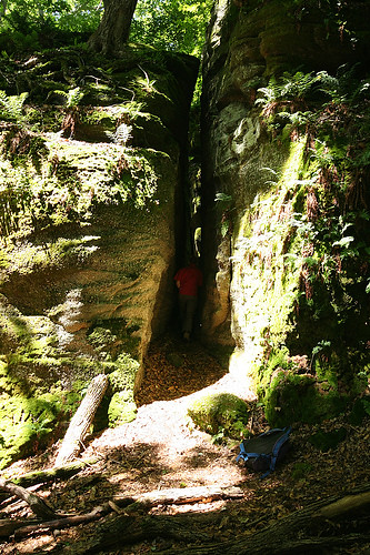
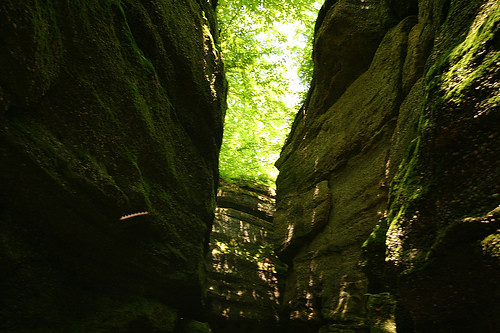
The park exists because it has lots of cool rock formations created by ancient glaciers dumping a bunch of boulders in a big pile. The trail map that I had only indicated about 1.8 miles of marked trail. We had chosen a short hike because Melissa was not feeling well, and because I wanted to break in my boots. The park is small, but filled with tons of little rock caves, cliffs, ravines, ledges, and climbs to explore. Between those exploring side trips and a couple miles of unmarked trail that we went on, we probably went closer to 4 miles total.
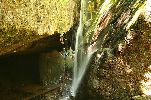
All of the marked trails in the park start from the same trailhead. Several of the trails simply run parallel to each other (S from the trailhead). The first (blue) basically runs along the bottom base of the rock ledges, the second (red) goes back over, under, and through some of the cool ravines and cliffs, and the third (white) sort of loops around up on top of the rock formations. We definitely followed the first two well beyond (S) their marked ends, farther into the woods. There are a few cool rocks back that way, but the trails do take you through the best sections. Also, at the end of the marked blue and red trails, there are some neat caves, with a creek coming down from a small waterfall which you can easily see from the white trail. There is one final trail, which runs N of the trailhead that takes you to a few more cool caves and to a neat, somewhat bigger waterfall. This one is maybe 40-50 feet high, but the water volume is pretty low, just a small creek about a meter wide a couple inches deep. We didn't see much wildlife other than a couple of frogs (one almost the size of my fist), but we were making plenty of noise and weren't really looking. I brought along my binocs, but never actually had a use for them.
The trails were not particularly well marked, but it's not a big deal since it is a pretty small park, and half the fun is going off the trails climbing and exploring in the various rock formations. The biggest downside was definitely the man-made junk all through the park. In most of the caves there were lighters and beer cans littered about. The trails rarely get out of sightline, and never get out of earshot, of the road. We passed a few other groups of people in the park, but the trails were certainly not crowded. This is definitely not a park for anyone who wants to get away from civilization and feel alone in the wilderness. But I highly recommend it for a fun hike with some scrambling around on rocks.
It was a gorgeous day, about 70 and sunny. We brought bagel sandwiches to eat after the hike, but everyone was hungry, so we ate before instead. We did not carry any water with us, so we were all extremely thirsty by the end. It was fine, however, since we were only gone for 2 hours, and we never really got very far from the car. By next weekend we should have our new backpacks with our water bladders to carry plenty with us. Also, it will be nice to have the packs for Melissa's camera, especially since some of the rock climbing required two hands and we had to pass the camera around to keep it safe. My binocs were OK since I carried them in the case because I am missing one of the lens caps.
My boots worked out well. They had pretty good traction, but I did still slip on a few of the wet rocks. I really appreciated the ankle support. I have two minor complaints. The first is that my feet are different by about a half size, so one boot fits perfectly and the other is just a touch loose. I think it will be fine, however, and I had no blisters or irritation whatsoever - amazing for the first time wearing brand new shoes. The second minor thing is that the top of my left ankle was a bit sore. I think it mostly had to do with how I had the laces tied and it should also be fine, but it is something to look out for.
My fiance Melissa took all of the pictures I posted here. She is an awesome photographer. One of these days I will make a post about here photography-awesomeness.
Subscribe to:
Posts (Atom)